Bangladesh Floods,August 2024
Understanding one of South Asia’s most severe flood events using FastFlood
In August 2024, Bangladesh experienced one of its most devastating floods in recent decades. Triggered by intense monsoon rainfall and water surges from upstream catchments in India, the event inundated vast areas across the north and northeast. According to national reports and international media, more than five million people were affected, with thousands displaced as rivers, including the Brahmaputra, Surma, and Kushiyara, overflowed their banks. Infrastructure, croplands, and homes suffered extensive damage, particularly in Sylhet and Sunamganj, where water levels reached some of the highest on record.
To reconstruct and understand this event, the FastFlood model was applied across the country. The aim was to assess how hydrological and meteorological drivers combined to produce such widespread flooding and how accurately large-scale flood models can represent real-world impacts.
Precipitation Analysis
Using NASA’s GPM (IMERG) satellite data, rainfall patterns were analysed throughout August 2024. Heavy precipitation peaks were observed around mid-August, following already wet conditions in May and June. This sequence of successive rainfall events left soils saturated and infiltration capacity minimal, amplifying surface runoff across major basins. The spatial distribution of total rainfall revealed localized accumulation exceeding 600 mm over eastern Bangladesh, driving extreme runoff along transboundary rivers. This asymmetric rainfall pattern caused concentrated flooding in the northeast while southern regions experienced less intense, but still significant, inundation.
Model Setup and Results
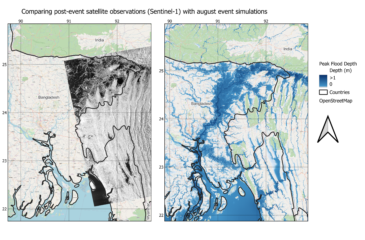
The event was simulated using FastFlood, integrating global datasets with national topographic and hydrological inputs. Soil infiltration, channel networks, and land-cover data were automatically parameterized, while rainfall was used as dynamic forcing. The results show extensive flooding along the Kalin, Titas, and Khayal rivers and widespread inundation throughout the Surma-Kushiyara basin.
Comparisons with available Sentinel-1 radar data and Bangladesh Flood Forecasting and Warning Centre (FFWC) maps demonstrated close agreement in flood extent and spatial patterns. Despite cloud cover limiting optical imagery, radar-based assessments confirmed the FastFlood simulation’s accuracy in capturing both the extent and intensity of the event.
Validation and Observations
Hydrological station data from the Bangladesh Water Development Board (BWDB) was used to validate modelled water levels. Observed and simulated peaks showed strong correlation, particularly in the northeastern stations, confirming that the model effectively reproduced both the timing and the magnitude of the event. Minor underestimations in some low-lying regions are attributed to channel storage and local embankment effects not represented in the input datasets.
The August 2024 floods highlight the growing vulnerability of Bangladesh’s deltaic landscape under compounding climatic pressures. The FastFlood model enabled a rapid, data-driven analysis of this large-scale event, supporting a better understanding of hydrological responses across complex river networks. These results will be instrumental in improving future forecasting capabilities, flood preparedness, and adaptation planning.
Image credits: NASA, Planet Labs