Kazakhstan Floods 2024, When Snow and Rain Collide
Post Disaster Flood Simulations: Kazakhstan, 2024
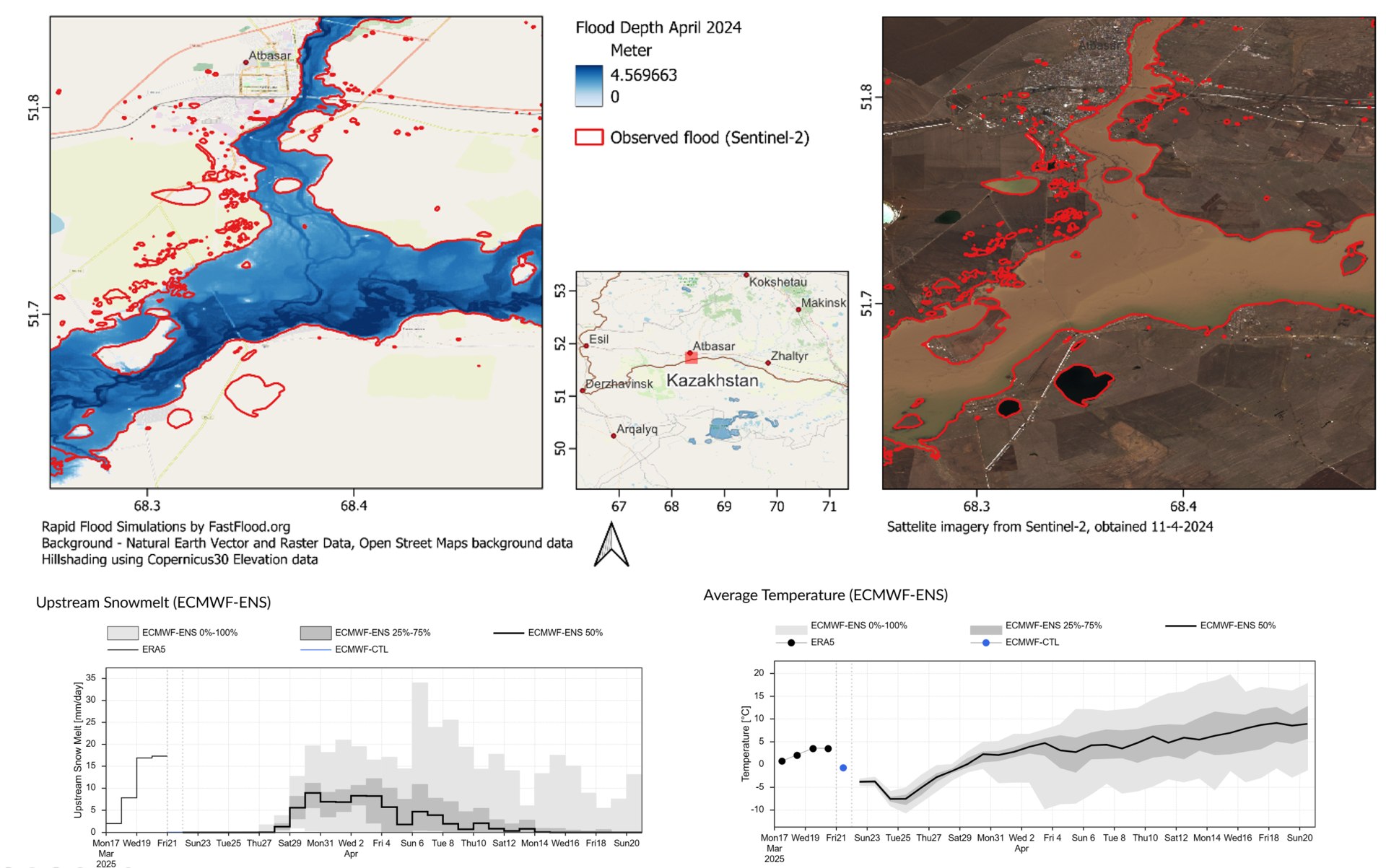
During April and May 2024, Kazakhstan experienced one of its most severe and widespread flood events in recent history, triggered by a rare combination of heavy snowmelt and intense spring rainfall. Rivers across northern and western Kazakhstan, including the Ural and Ishim systems, rapidly overtopped their banks, inundating towns such as Uralsk, Petropavl, Orsk, Aktobe, and Atbasar. Thousands of residents were displaced, infrastructure was damaged, and floodwaters spread across agricultural plains that remained saturated for weeks.
To analyse and reconstruct the event, simulations were performed using the FastFlood rapid flood modelling framework. This physically based model was calibrated using discharge measurements from the Kazakhstan Hydrometeorological Department and validated against Sentinel-2 satellite imagery showing flood extents between April and May 2024. The model relied on the Copernicus 30 m DEM for national coverage and WorldDEM Neo 5 m elevation data for urban-scale simulations, capturing fine terrain variations essential for flood routing.
The simulations achieved high performance and accuracy across most regions. Flood extent validation indicated agreement levels above 95–98%, while water-level and discharge deviations averaged between 2–4%, depending on data availability. The Ural and Ishim basins were particularly well represented, with flood propagation and depth patterns aligning closely with observed inundation. Local-scale simulations for Petropavl, Uralsk, and Atbasar also matched observed flood limits, even in densely built-up environments. In contrast, areas such as Aktobe and Orsk, influenced by complex reservoir operations and levee breaches, highlighted the limitations of rapid simulations when infrastructure and management data are scarce.
Model analysis showed that the main driver of the floods was a sudden rise in temperature at the end of March, which triggered rapid snowmelt over extensive frozen basins. This melt coincided with heavy rainfall, compounding the runoff and producing discharge peaks that far exceeded historic norms. The resulting flood wave moved swiftly downstream, submerging low-lying settlements and reactivating old meander channels and oxbow lakes that had long been disconnected from the river system.
Overall, the event demonstrated the value of fast, data-driven, and physically based flood simulation systems for post-event analysis and emergency response. FastFlood proved capable of reconstructing hydrodynamic behaviour across vast areas within short timeframes, using globally available datasets and minimal local calibration. Such approaches are essential for rapid damage assessment and preparedness planning in regions, especially where data access is limited or fragmented.