Nationwide Flood Modelling for Cambodia
A Hybrid Approach to Understanding the Mekong using FastFlood
Flooding along the Mekong River remains one of Cambodia’s most persistent and complex natural hazards, driven by both riverine (fluvial) and intense rainfall (pluvial) processes. From July to September 2025, floods associated with the Mekong and flash-flooding episodes killed 19 people, affected over 31,000 families, inundated more than 12,000 houses, and damaged thousands of hectares of rice and other crops. Other episodes earlier in the year saw heavy rain inundate 1,471 hectares of rice fields in Kampong Thom alone.
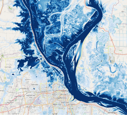
To bolster national-scale understanding of these events and assess future risk, a comprehensive nationwide flood simulation was carried out using FastFlood, combining globally available datasets, high-resolution terrain data, and physically-based hydrodynamic modelling. The approach followed a hybrid workflow: an initial nationwide simulation at around 300 m resolution, followed by refinement to 30 m resolution using the refine option of FastFlood’s command-line tool. This ensured that both broad-scale flood behaviour and finer local inundation dynamics were captured.
Model inputs utilised global open-source datasets: Copernicus 30 m land-use/infiltration data, design storms derived from the ERA5‑Land reanalysis, and boundary discharge from bias-corrected GloFAS datasets. Model outputs were calibrated against the Copernicus Global Surface Water Explorer, which leverages over 30 years of satellite imagery to map surface water presence. While this calibration dataset is robust for sustained inundation, it is important to note that short-duration flash floods (especially on smaller channels) may not be fully captured due to satellite revisit constraints.
The calibration process in FastFlood employed built-in optimisation of Manning’s surface roughness and infiltration rates, resulting in strong alignment between simulated extents and observed water presence. The final deliverables included a set of return-period flood maps covering pluvial and fluvial events for Cambodia, and future scenario simulations under SSP2-4.5 and SSP5-8.5 climate pathways based on NASA downscaled CMIP6 datasets.
With the latest versions of FastFlood Global and the command-line tool, running national-scale high-resolution simulations is now feasible without the need for an initial coarse run. Users can directly model entire basins or countries at 30 m resolution, enhancing speed and fidelity in large-area flood analysis.