FastFlood Docs
Your First Simulation
Starting the Model
The fastflood model can be opened by going to www.fastflood.org. Once you visit the website, you are greeted by the main interface of the model.

The map of the world indicates the areas you can model, any place you wish!

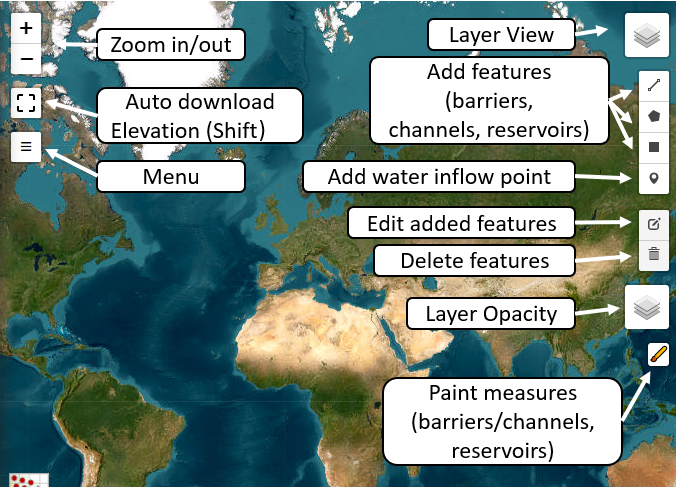
Once you close the welcome message, the tool hints appear. Press the menu button on the left to open the menu.
Within the menu, you can input data and simulation settings, and you can find the Simulate button at the bottom.
Simple Rainfall-fed Flooding
Select the auto-download elevation button and drag a rectangle on the map. This will prompt the auto-download menu for input elevation data.
You are presented with several options so that you can define the resolution (size of each pixel in the model) in such a way that simulations are fast enough for your use-case.
It is good practice to start out with a fast simulation setup; this will allow you to refine your ideas and spend more time on detailed simulations later on.
For now, the example area is approximately 60px by 600px with a resolution of 20 meters, which simulates instantly on laptops, computers, and even phones. Note that a larger model domain will also increase simulation time. If your browser warns you the website is stuck, it might very well be simulating in the background.

If you press the simulate button, the progress dialog will show, and once finished, the flood results for an arbitrary default rainfall event will overlay on top of the model. Using the shift button, you can inspect elevation and flood height values within the map.

Next, we will define our own rainfall scenario.
Precipitation Scenarios
In the chosen example, the source of water in the simulation is precipitation. This means we must define an intensity (possibly spatial) and duration for the event. Within the menu, you can find the precipitation tab. Here, we can start out by altering the intensity and duration of the event.
Both a lower intensity and lower duration will alter the flood heights, as the total amount of water fed into the system is lower. The actual relationship is complex and depends on flow velocities, flow path lengths, and topographical patterns of the landscape.

Settings
Currently, the results indicate a simple flood map, resulting from a rainfall and surface roughness coefficient that is homogeneous in space. There are a couple of important things to note about the default settings:
- Ignore reservoirs and depressions (slightly faster, and works better in large-scale simulations)
- Do not correct for non-linearity in stage-discharge relationships (slightly faster)
- Do not correct for pressure-driven flow paths (slightly faster)

Each of these can be enabled under the settings menu, and should allow for effective and accurate flood simulation in a variety of settings:
- Flash floods: All settings might be turned off, fastest and accurate.
- Fluvial floods: Non-Linear correction (and perhaps flat terrain) turned on, fast and accurate.
- Urban floods: Flat terrain turned on, fast and accurate.
The quality of the model output depends predominantly on the quality of the elevation model. Where precipitation and surface roughness might be manually tweaked to obtain good results, elevation data is often a limiting factor. Some settings might also help with improving accuracy, so experiment with those if you run into trouble.
Analysis
Some simple analysis can be carried out. Under the menu view item, you can select a histogram of the flood depths. You can also show the average flood depth per land cover class.
